

The barrier island that we now know as Honeymoon Island has, across its documented history, been the site of a remarkable concentration of architectural and developmental ambition — most of it now invisible. To walk Honeymoon Island today is to walk past evidence of what was built and what was lost, what was preserved and what was deliberately not built, and what the cumulative record of a century of decisions actually produces in physical form. This is more than a story about a beautiful Florida state park. It is a story about how specific architectural choices, made by specific developers and protected or constrained by specific civic actions, produced the present-day island we inherit.
I have written elsewhere, in my LinkedIn article What Honeymoon Island Reveals About What Florida Almost Lost, about the broader civic story of how the island’s preservation came to be. That article makes the case that grassroots civic action across the late 1960s and 1970s prevented the comprehensive residential development that other Florida barrier islands experienced, and that the Honeymoon Island we encounter today is the result of those specific civic decisions. The MiddletonTampaBay companion piece, Honeymoon Island and the Dunedin Causeway: A Resident’s Practical Guide, translates that history into practical guidance for buyers, residents, and visitors who want to understand how the island fits into daily life in Dunedin.
This Journal piece does something different. It is the architectural and built-history record of the island itself — what was actually constructed at each stage of the island’s modern history, what survives, what is lost, and what the surviving and lost structures reveal about the broader pattern of Florida coastal development across the twentieth century. For readers who want substantive architectural detail rather than broader civic argument or practical guidance, this piece is the dedicated treatment.
Honeymoon Island has been many things across its documented history: a Tocobaga harvesting site for centuries before European contact, a Spanish-noticed but unoccupied geography in the 1500s, a 19th-century site of marginal logging and feral hog populations that gave it the name Hog Island, a 1921 hurricane-split barrier island that became the proximate ancestor of present-day Honeymoon Island and Caladesi Island, a 1939 honeymoon resort experiment, a WWII rest-and-relaxation facility for defense workers, a 1953 Dunedin annexation, a late-1960s and early-1970s residential development site, and from 1981 onward, a state park. Each of these phases produced built artifacts. Most of those artifacts are now gone. The few that survive constitute the only architectural evidence of what the island has actually been across its modern history.
This is the comprehensive built-history record I have been able to assemble.
The Pre-Modern Geography
Before discussing built structures, the geographic prerequisites need to be clear, because the island’s specific configuration is itself the foundational architectural fact of the entire subsequent history.
What we now call Honeymoon Island was originally part of a single barrier island known as Hog Island, which extended along Florida’s Gulf coast roughly parallel to what is now Dunedin. The island had been recorded on Florida maps from approximately 1830 onward, generally as Sand Island in the earliest cartographic records before the Hog Island name became standard following the introduction of feral pig populations during 19th-century logging activities.
In October 1921, a major hurricane struck the Tampa Bay region. The storm carved a new pass through the middle of Hog Island, splitting it into two separate landmasses with the new waterway between them — quickly named Hurricane Pass — connecting Saint Joseph Sound to the Gulf of Mexico. The southern fragment was officially renamed Caladesi Island in 1928 (a name derived from the Spanish “calida,” meaning warm). The northern fragment continued as North Hog Island for another decade.
This is the single most consequential geographic fact in the island’s modern history. Without the 1921 hurricane, there would be no Honeymoon Island. There would be only the larger Hog Island, with whatever subsequent development pattern that single larger island would have attracted. The hurricane created the geographic conditions that made all subsequent built history possible — the smaller, more discrete Honeymoon Island that Clinton Washburn purchased in 1938, the smaller-scale residential development that emerged in the late 1960s, the more manageable footprint that the state acquired in 1974-1981. Each of these subsequent decisions operated within geographic boundaries that the 1921 storm established.
The 1921 hurricane also created the ecological conditions that made the eventual state park designation meaningful. The protected eastern (Saint Joseph Sound) shoreline, the relatively narrow western (Gulf-facing) beach, the upland slash pine forest interior, and the various intermediate habitats that define Honeymoon Island today are all functions of the specific size and shape produced by the 1921 storm. Different hurricane geometry would have produced different ecological conditions, and the resulting island would not have offered the same biodiversity or natural amenity profile that justifies the present-day state park.
This is, in a sense, the first architectural fact of Honeymoon Island’s modern history — the 1921 hurricane functioning as the original architect, establishing the spatial constraints that all subsequent human construction and conservation would operate within.
The Washburn Era (1939-1942)
The first substantial human construction on Honeymoon Island in its modern era began in 1939 (some sources date the purchase to 1938), when New York developer Clinton M. Washburn purchased the island for $25,000. The Washburn era produced what was, in retrospect, one of the more architecturally distinctive but architecturally short-lived ventures in the island’s history.
Washburn’s concept was to develop the island as a destination resort for newlyweds. The marketing campaign — initiated through Washburn’s friendship with Joseph Bryce, then editor of Life magazine — generated national publicity and the rebranding from North Hog Island to Honeymoon Island. By March 1940, Washburn had constructed approximately fifty thatched-roof cottages on the island, along with several supporting structures. According to surviving accounts, the development included:
Fifty thatched cottages. These were small, simple, single-room structures built in a Polynesian-inspired style with thatched roofing materials. The thatched aesthetic was a deliberate marketing choice rather than a reflection of native Florida architectural traditions — Washburn was selling a tropical-paradise fantasy, and the thatched cottages were part of the visual vocabulary. Each cottage was apparently sized for a single newlywed couple, with shared communal facilities for showers, toilets, and dining.
A “king’s palace.” The surviving accounts describe a central structure variously referred to as the “king’s palace” — likely a small Polynesian-themed central pavilion that functioned as a recreational and gathering hub for the resort. The exact architectural character of this structure is not well documented in the surviving record, but it appears to have been the most ambitious of the Washburn-era buildings.
A chapel. A small chapel was constructed for the wedding ceremonies that the resort marketing emphasized. Many of the 164 honeymooning couples reportedly used the chapel for their actual wedding ceremonies before beginning their honeymoon stays.
A recreational hall with dance pavilion. A larger structure for evening entertainment, dancing, and group activities. Likely the second-largest of the Washburn-era buildings after the king’s palace.
A water tower. A small water tower providing fresh water to the resort facilities.
A community house. A central structure containing showers, toilets, and lavatories serving the cottage residents.
Together these structures constituted what Washburn called Honeymoon Village — a complete small-resort built environment occupying a portion of the southern end of the island. The first honeymooners — Marjorie and Earnest Burkett — arrived on March 8, 1940. In all, 164 couples participated in the Washburn experiment before the United States’s entry into World War II in December 1941 forced the project to wind down.
Following the U.S. entry into the war, the island was leased to an Ohio defense contractor as a rest-and-recuperation facility for his defense-industry employees. The cottages remained in use during the war years, though their character shifted from honeymoon-themed to industrial-recreation-themed. After the war, the cottages and supporting structures fell into disrepair, the resort never resumed operation, and the buildings were progressively lost to neglect, decay, vandalism, and storm damage across the postwar decades.
By the time the state of Florida began acquiring the island in 1974, virtually nothing of the Washburn era survived. The last fragments of the cottages and supporting buildings were either deliberately removed during the state park preparation or had already been destroyed by previous weather events. Photographic evidence of the Washburn era survives in archives, including images of the first honeymooning couple at the resort and various postcards from the early 1940s. The buildings themselves are entirely lost.
This pattern — of substantial built infrastructure being constructed, used briefly, and then disappearing into the historical record — is characteristic of much early 20th-century Florida coastal development. Buildings constructed as marketing devices for resort or development concepts rarely survive the failure of the underlying business plan. The Washburn cottages are one example. The various lost resort developments along the Gulf coast through the 1920s and 1930s are others.
What remains of the Washburn era is, essentially, only the name. Honeymoon Island retained its Washburn-era branding when the state of Florida designated it as a state park in 1981, despite the obvious irony that the actual honeymoon resort had been gone for nearly forty years by that point. The name has continued to function as a marketing asset for Florida state tourism even as the original architectural manifestation of the name has been entirely erased.
The 1953 Annexation
In 1953, Dunedin formally annexed both Honeymoon Island and Caladesi Island, along with approximately 3,000 acres of adjacent submerged lands transferred from state ownership. This was a civic-political action rather than a building project, but it was one of the most consequential decisions in the island’s modern history because it established the municipal jurisdictional framework within which subsequent development and preservation decisions would occur.
The annexation gave Dunedin legal authority over the islands’ development. Without this annexation, decisions about what could be built on Honeymoon Island would have been made at the county level, with different political dynamics and different incentive structures. The Dunedin civic culture, by 1953, was already oriented toward preservation of the town’s natural and architectural character — the same orientations that had preserved the historic core of downtown Dunedin and would later support the broader regional preservation movement.
This is worth emphasizing because the architectural future of Honeymoon Island was being shaped, in 1953, by a civic decision about jurisdiction. No buildings were being constructed. No preservation actions were being taken. But the framework that would eventually allow for both substantial residential development (the Royal Stewart Arms, completed 1973) and substantial preservation (the state park, formally designated 1981) was being established through this jurisdictional choice.
The Late-1960s Development Pressure (1965-1972)
The most consequential threat to Honeymoon Island’s eventual conservation came in the late 1960s and very early 1970s, when developer Tom Green acquired significant portions of the island and proposed an ambitious residential development project.
The original Green plan called for substantial dredging-and-filling to expand the island’s developable area, multiple high-rise residential towers, dredged channels for boat access, supporting infrastructure including a causeway expansion and additional bridge facilities, and the kind of comprehensive built environment that other Florida barrier islands had received during the same period. If completed at the original scale, the Green project would have transformed Honeymoon Island into a residential community comparable to what was simultaneously being developed at Clearwater Beach, Indian Rocks Beach, Madeira Beach, Treasure Island, and St. Pete Beach during the same era.
Construction on the first elements of the Green project began in 1967, with the foundational work for what would eventually become the Royal Stewart Arms. However, the broader Green plan encountered the regulatory and civic resistance that I have detailed at length in the LinkedIn article on this subject. The Florida state and U.S. Army Corps of Engineers refused to renew Green’s dredging permit in late 1969. Grassroots citizen organizing through SAVE (Suncoast Active Volunteers for Ecology), led by Dee Dubendorff and beginning in 1970, sustained pressure that ultimately produced negotiations between Green and the state. The broader development plan was abandoned, and what was completed was substantially smaller than what had been originally proposed.
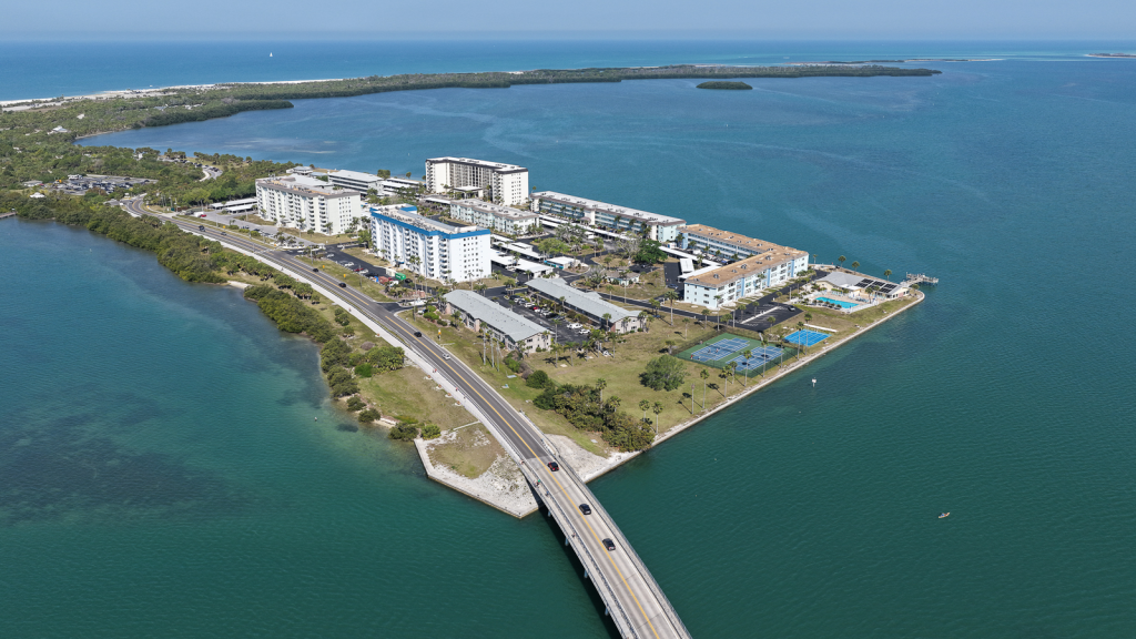
The Royal Stewart Arms — the eight residential buildings completed in 1973 on 23 acres of the island’s southern end — represents the surviving architectural artifact of what would have been a much larger development. Walking the island today and standing at the southern end near the Royal Stewart Arms is an experience of looking at architectural evidence of two histories simultaneously: the development that actually occurred, and the much larger development that almost did. The fact that only 23 acres of Honeymoon Island contain residential built infrastructure is itself an architectural fact, and the rest of the island’s preservation as state park is the inverse architectural fact — what was deliberately not built.
The Royal Stewart Arms (1967-1973)
For a Journal piece on the architectural history of Honeymoon Island, the Royal Stewart Arms requires substantive treatment because it is the most consequential surviving built environment on the island and the only significant residential architecture that remains.
The Royal Stewart Arms was completed in 1973, with construction having begun in approximately 1967 as part of the broader Green development plan. The project occupies 23 acres of the southern end of Honeymoon Island and consists of eight residential buildings comprising 449 individual condominium units. The architecture is characteristic of late-1960s and early-1970s Florida coastal residential development — multi-story (eight-story) reinforced concrete buildings with simple modern aesthetics, rows of balconies with decorative railings, and the prioritization of efficient unit density and ocean views over architectural distinctiveness.
The buildings are not architecturally celebrated. They are functional examples of an era’s mass-residential approach to coastal development. They do, however, possess substantial historic significance in two specific senses.
First, they are surviving examples of late-1960s and early-1970s Florida barrier-island residential architecture in a context that almost everywhere else of similar character is now substantially altered or lost. Across most of Florida’s Gulf coast, the residential construction of this era has been progressively replaced by newer luxury condominium development as land values have increased and original buildings have aged out of viability. Royal Stewart Arms remains substantially in its 1973 configuration, with buildings retaining their original architectural character despite ongoing maintenance and updating of individual units.
Second, they represent the abandoned trajectory of what Honeymoon Island almost became. Standing at the Royal Stewart Arms entrance and looking outward across the rest of the island that remained undeveloped is a specific architectural experience — encountering the only built residential evidence of an aborted development plan that, had it proceeded, would have transformed every part of the island visible from this vantage point. The Royal Stewart Arms is, in this sense, the architectural expression of a counterfactual — the surviving fragment of what almost was.
The community continues to operate today as a 55+ deed-restricted condominium development with its own homeowners association, recreational facilities (clubhouse, fishing pier, fitness center, swimming pool, tennis courts), and the kind of mature 1970s-era residential community character that has substantially survived the past half-century. Property values in the community have remained moderate for the area, reflecting the unusual combination of Honeymoon Island address with the somewhat aging architectural character of the buildings themselves.
For readers approaching this Journal piece from the historic-real-estate perspective, the Royal Stewart Arms represents a specific market opportunity that warrants understanding. The combination of unique island address (a Honeymoon Island address is genuinely irreplaceable), substantial unit inventory (449 units distributed across eight buildings), 55+ community character, and moderate pricing relative to comparable Tampa Bay coastal real estate creates buyer profiles different from those who pursue traditional historic homes elsewhere in the region. Some of my own client work has involved Royal Stewart Arms transactions, and the patterns there are genuinely distinct from what occurs in the broader historic Tampa Bay residential market.
The State Park Designation (1974-1981)
The formal preservation of the rest of Honeymoon Island as protected state park land occurred in two phases.
Phase 1: Initial state purchase, 1974. The state of Florida purchased 113 acres of Honeymoon Island as the foundation of what would eventually become the state park. This initial purchase represented the first substantial conversion of private development-focused ownership to public conservation-focused ownership, establishing the precedent for the further acquisitions that would follow.
Phase 2: Subsequent acquisitions, 1974-1981. Over the following six years, the state of Florida acquired the remaining undeveloped parcels of the island, ultimately consolidating approximately 2,800 acres under state park ownership and management. The final consolidation produced the geographic configuration that defines today’s state park — substantially the entire island except for the 23 acres occupied by the Royal Stewart Arms.
Phase 3: Formal park designation, December 7, 1981. Honeymoon Island State Recreation Area was formally established. The designation represented the institutional culmination of the protective work that civic action and regulatory intervention had made possible across the preceding fifteen years.
From an architectural perspective, the state park designation is significant primarily for what it prevented from being built. The roughly 2,800 acres of preserved island represent a counterfactual architectural future that did not occur. Had the original Green development plan proceeded, those 2,800 acres would have contained a comprehensive residential and resort built environment comparable to the developed portions of comparable Florida barrier islands. What we encounter today as preserved nature is the architectural negative — the specific shape of what was deliberately not built.
The state park has constructed limited supporting infrastructure across its history: bathhouses, picnic facilities, interpretive signage, the Rotary Centennial Nature Center (a more recent addition), parking facilities, and the various trail systems including the Osprey Trail and the Pelican Cove Trail. These structures are functional and unobtrusive rather than architecturally distinguished. They serve the preservation mission of the park rather than competing with it for visual or experiential attention.
The state park infrastructure has also experienced significant storm damage and rebuilding cycles across recent years. Hurricane Helene in September 2024 produced substantial damage to bathhouses and other facilities, with recovery work continuing through 2025 and 2026. This pattern of periodic storm damage and rebuilding is itself part of the architectural reality of operating a state park on a barrier island — a continuous cycle of construction, damage, removal, and reconstruction that reflects the inherent vulnerability of barrier-island built infrastructure to Gulf coast storm exposure.
The Causeway and Bridge Infrastructure
A complete architectural account of Honeymoon Island requires attention to the causeway connecting the island to mainland Dunedin, because the causeway is itself substantial built infrastructure and is essential to the island’s accessibility and functional character.
The Dunedin Causeway extends approximately two miles from the mainland to the southern end of Honeymoon Island. The original causeway construction occurred in conjunction with the late-1960s development era — the same period that produced the Royal Stewart Arms — and replaced earlier ferry-and-boat access patterns that had served the island during the Washburn era and immediate postwar period. A drawbridge was constructed as part of the causeway development, allowing boat traffic to pass between Saint Joseph Sound and the Gulf without requiring extensive detours.
The causeway and bridge infrastructure have been progressively updated, replaced, and reinforced across the subsequent decades. The original drawbridge has been replaced. The causeway itself has been reinforced and updated to current Florida road and storm-resistance standards. The Pinellas Trail, the 47-mile rails-to-trails corridor that forms one of the most consequential pieces of recreational infrastructure in Tampa Bay, was extended to connect to the causeway during the 1990s, providing protected non-vehicle access to Honeymoon Island that had not previously existed.
The causeway is, architecturally speaking, the most consequential piece of built infrastructure connecting Dunedin proper to the broader Honeymoon Island geography. Its design choices — the elevation, the drawbridge specifications, the lane configuration, the trail integration — all reflect specific civic and engineering decisions that have shaped how residents and visitors actually access the island. Different causeway design would have produced different access patterns, different relationships between mainland and island, and different functional use of the island over the past half-century.

What This Architectural History Reveals
Stepping back from the specific built record, the architectural history of Honeymoon Island reveals several broader patterns worth articulating.
Most of what was built on Honeymoon Island is now lost. The Washburn cottages, the king’s palace, the chapel, the dance pavilion, the WWII-era defense-industry facilities — none of these structures survives. What was constructed during the 1939-1942 era, despite its specific cultural significance and the substantial investment it represented, has essentially disappeared from the physical record. Only photographs, archival materials, and the residual name “Honeymoon Island” preserve any trace of the era.
The surviving built environment represents a specific era’s architectural sensibility. The Royal Stewart Arms, completed 1973, is the dominant surviving residential built environment on the island. Its architecture is functional rather than distinguished, characteristic of late-1960s and early-1970s Florida coastal residential development. The state park supporting infrastructure (bathhouses, picnic shelters, the Rotary Centennial Nature Center) is similarly utilitarian. The total built record of what survives on Honeymoon Island today is, in architectural terms, modest.
What is most consequential about the island’s architectural history is what was deliberately not built. The 2,800 acres of preserved state park represent a counterfactual architectural future — the comprehensive residential and resort development that could have occurred on the island but did not, because specific civic and regulatory actions prevented it. This negative architecture, in a sense, is the most distinctive architectural fact of the island. The preservation is itself an architectural choice, even though it manifested as decisions not to build rather than as decisions to build.
Storm cycles continuously reshape both the natural and built environments of barrier-island Florida. The 1921 hurricane that created Honeymoon Island geographically. The hurricanes that damaged Washburn-era buildings during their brief existence. Hurricane Helene in 2024 and Hurricane Idalia in 2023 that damaged state park infrastructure and the Royal Stewart Arms. The cumulative effect of periodic major storms has been to continuously modify both what exists naturally on the island and what humans have constructed there. This is not unique to Honeymoon Island but is characteristic of all Florida barrier-island built environments — the architectural reality of building and preserving in a hurricane-prone coastal geography.
The architectural narrative of Honeymoon Island is also the architectural narrative of broader Tampa Bay barrier-island history. Most barrier islands along the Gulf coast experienced comprehensive residential and resort development across the postwar decades. Honeymoon Island represents the rare exception. Walking the preserved 2,800 acres of state park today is walking through a pre-development version of what Tampa Bay’s coastal geography mostly looked like before the postwar development era — a specific historical artifact preserved through specific civic action against the broader regional pattern.
A Closing Observation
For readers who arrive at this Journal piece interested in the architectural and historic depth of Tampa Bay’s barrier-island history, Honeymoon Island represents one of the more distinctive case studies available in the region.
The lost Washburn-era buildings would, had they survived, represent a unique example of late 1930s Florida resort architecture, with their thatched-roof aesthetic and Polynesian-inspired design vocabulary. Their loss across the postwar decades was not architecturally decisive — comparable resort developments elsewhere in Florida have similarly been lost, and the Washburn cottages were not architecturally distinguished by the standards of their era. But their disappearance does represent a specific kind of cultural loss: the erasure of a brief and ambitious mid-century cultural experiment about what Florida coastal life could look like.
The surviving Royal Stewart Arms represents a different kind of architectural record — one where the buildings themselves are not particularly distinguished but where the historical significance lies in what the buildings represent (the specific 23-acre exception within an otherwise preserved island) and in the architectural counterfactual they invoke (the much larger development that almost was).
The preserved state park represents the most distinctive architectural feature of all — the deliberate negative, the specific shape of what was deliberately not constructed across decades when Florida’s broader coastal development pattern produced very different outcomes elsewhere. To walk the Osprey Trail today is to walk through an architectural choice — the choice to preserve old-growth slash pine forest rather than to build over it, the choice that civic actors made and that we now inherit.
For my work in real estate specifically, the Honeymoon Island built history matters because it shapes the present-day market dynamics of Dunedin properties with proximity to the island. Buyers who recognize what the preservation represents — the specific civic actions that made the present landscape possible, the counterfactual development that almost was, the architectural choices both made and refused — are often the buyers who place highest value on Dunedin residential properties in the historic core and along the older waterfront streets. They are responding to the cumulative architectural and civic history that this Journal piece has tried to document.
The buyers who do not recognize what they are responding to often pay similar premiums for the same properties without the same depth of understanding. They are responding to qualities they cannot quite articulate — the sense of place, the natural amenity, the residential character that the preservation produces — without recognizing that those qualities are the result of specific past architectural and civic choices that someone made at some moment in the island’s documented history.
Either way, the Honeymoon Island we inherit today is the cumulative product of all the choices I have described above. Walking the preserved 2,800 acres of the state park, looking at the Royal Stewart Arms condominiums, crossing the Dunedin Causeway, and ultimately encountering the broader Dunedin residential fabric across the bay is to experience the full architectural and built history of one of Florida’s most distinctive surviving barrier islands.
For readers who want the broader civic argument about what this preservation represents, my LinkedIn article on what Honeymoon Island reveals about what Florida almost lost makes the case at length. For practical guidance on how the island fits into daily life in Dunedin and what this means for buyers and residents, my MiddletonTampaBay practical resident’s guide covers the operational details. For the broader Dunedin context — why the town belongs in the conversation about America’s best small towns generally, the architectural and historic depth of its historic homes, and the comprehensive practical guidance for buyers and residents — my LinkedIn article on Dunedin, my Journal piece on Dunedin’s historic homes, my documentary Delightful Dunedin, and my Living in Dunedin Guide collectively constitute the substantive resource library on the town and its surrounding landscape.
This Journal piece on the built history of Honeymoon Island specifically is the architectural-record companion to all of those broader resources. For readers serious about understanding what Tampa Bay’s barrier-island architectural history actually consists of, and what the choices of the past century have produced in physical form, the Honeymoon Island case is one of the most consequential available.

Considering a Dunedin Historic Home or a Royal Stewart Arms Condominium?
Whether you are evaluating a historic Dunedin residence, considering a Royal Stewart Arms condominium, exploring Dunedin’s broader real estate landscape, or simply researching the architectural history of Tampa Bay’s barrier islands, I would welcome the conversation. Every property purchase is specific, and the right approach depends on the property, your goals, your timeline, and what you are actually trying to accomplish.
Call 727-871-SOLD (727-871-7653) or reach out through the Contact page to start the conversation.